JustRouting MCP
Roteamento de rotas e otimização de frotas para o Sudeste Asiático a partir de qualquer cliente MCP. Calcule rotas de carro e moto, matrizes de tempo de viagem, geocodificação e planos de entrega com múltiplos veículos via a API JustRouting. Plano gratuito; chave de API necessária.
Documentação
All-in-one, Just Routing APIs
Built for developers. Ready for AI agents. Super lightweight routing API. Start in 30 seconds.
Customized car and motorcycle profiles. Powered by open source. No DevOps, no sales calls, no surprise bills.
curl "https://api.justrouting.tech/route/v1/driving/103.708362,1.357371;103.984748,1.352212?overview=full" \
  -H "Authorization: Bearer YOUR_API_KEY"
# Prompt for an MCP-capable agent, e.g. Claude or Codex
How long does it take to drive from Marina Bay Sands Singapore to Changi Airport?
# > Distance: 19 km
# > Duration: 24 min

How about motorcycle?
# > Distance: 19 km
# > Duration: 27 min
Official MCP:curl -fsSL https://raw.githubusercontent.com/justrouting/mcp/main/install.sh | sh
Try It Right Now
Live Demo
Tips: Click [Run Demo] to fetch real directions from the API. You can also drag the (A)/(B) points to new locations, or add (A)/(B) via Command(Mac) or Ctrl(Windows) + Click
curl "https://api.justrouting.tech/route/v1/driving/103.708362,1.357371;103.984748,1.352212?overview=full" \
  -H "Authorization: Bearer e7d5c0f6c1da7752488610d21fd80959"
Vehicle:
This is a live demo with a real API key (feel free to steal it).
Want the full picture?
Want examples & SDK?
Routing Comparison
| Profile | OSRM | JustRouting | Google Maps |
|---|---|---|---|
| Car | 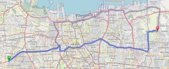 49.9 km, 39 min 49.9 km, 39 min | 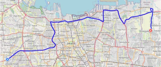 53.2 km, 1 h 23 min 53.2 km, 1 h 23 min | 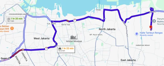 53.2 km, 1 h 22 min 53.2 km, 1 h 22 min |
| Motorcycle | Unsupported | 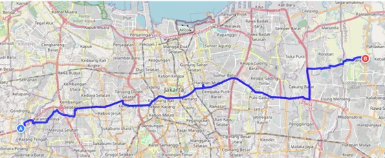 41.8 km, 1 h 50 min 41.8 km, 1 h 50 min | 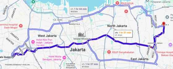 41.4 km, 1 h 31 min 41.4 km, 1 h 31 min |
Instead of applying a uniform route profile across all regions, we built different customized profiles for each country based on local map data quality and traffic conditions.
Pricing
Free
$0/forever
- 100 requests/dayi
- Distance matrix APIi 100x100 matrix size
- Fleet optimization APIi 10 vehicles / 100 jobs
- Car & Motorcycle routing profiles
- Southeast Asia coveragei
- No credit card required Get Free API Key
Hobby
$8/month
- 10,000 requests/dayi
- Distance matrix APIi 500x500 matrix size
- Fleet optimization APIi 50 vehicles / 1,000 jobs
- Car & Motorcycle routing profiles
- Southeast Asia coveragei
- Cancel anytime Get Started
Hitting the limits, want more countries, or need a bespoke solution? hello@justrouting.tech - we'll figure it out.
Education, non-profit, or open source?
We offer more free quota — email hello@justrouting.tech to connect.
What You Get
🧭 Directions & Maplines
Get road-following route geometry between any waypoints - ready to render on Leaflet, Mapbox, or any map library. Turn-by-turn instructions included.
🗺️ Distance Matrix
Compute travel times and distances between multiple points in a single request. Essential for logistics, dispatch, and planning at scale.
🚚 Fleet Optimization
Assign jobs to vehicles with optimal stop sequencing. Handle time windows, capacity limits, and multi-vehicle fleets - all in one solve.
📍 Map Matching
Snap GPS traces to the road network. Clean up tracking data and analyze actual routes driven with precision.
🔓 Open Standards
Built on OSRM, VROOM, and OpenStreetMap. No proprietary formats, no vendor lock-in - just open, portable data.
🎯 Optimized Routes
Instead of applying a uniform route profile across all regions, we built different customized profiles for each country based on local map data quality and traffic conditions.
Powered by Open Source: Built on OSRM (Open Source Routing Machine), VROOM (Vehicle Routing Open-source Optimization Machine), and OpenStreetMap data.
Coverage Area
The free tier covers Southeast Asia. Need more regions? Email me - coverage is added based on demand.
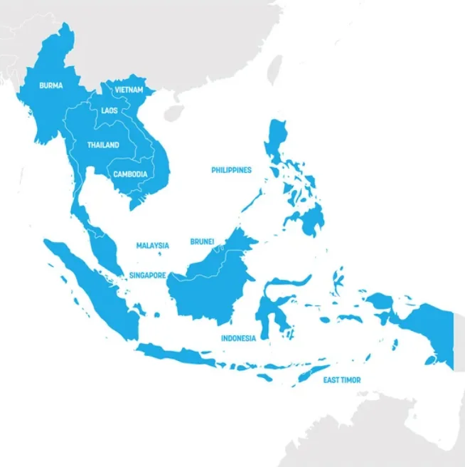
- 🇧🇳 Brunei
- 🇰🇭 Cambodia
- 🇮🇩 Indonesia
- 🇱🇦 Laos
- 🇲🇾 Malaysia
- 🇲🇲 Myanmar
- 🇵🇭 Philippines
- 🇸🇬 Singapore
- 🇹🇭 Thailand
- 🇹🇱 Timor-Leste
- 🇻🇳 Vietnam
Map Updates
Bi-weekly. Need more frequent, or need a hotfix immediately? Email me - map is updated based on demand.
| Update | Version |
|---|---|
| 2026-09-28T15:41:03Z | v2026.09.28(current) |
| 2026-09-12T15:23:31Z | v2026.09.12 |
| 2026-08-30T15:10:01Z | v2026.08.30 |
| 2026-08-20T15:07:52Z | v2026.08.20 |
| 2026-08-10T15:42:02Z | v2026.08.10 |
Why This Exists
Self-hosting OSRM means a 128GB server and ongoing DevOps work. Enterprise providers mean "contact us" pricing and sales calls. We wanted something in between - a super lightweight routing API you can start using in 30 seconds for $0. So we built it.
Not for you if: you need global coverage (SEA only right now), real-time traffic data, sub-10ms latency guarantees, or enterprise SLAs with legal contracts. No hard feelings.
Need something custom?
We also build custom solutions - routing stack deployments, custom routing integrations, geospatial data processes & pipelines, or anything in the routing/geo-data space. If you need a bespoke solution, let's talk.
FAQ
What's the catch?
No catch. The free tier subsidizes itself through the paid tier. We're not trying to get rich, just provide value at a fair price.
Is this production-ready?
For small-to-medium projects, absolutely. But if you need five-nines, sub-millisecond latency, and legal contracts, you probably need enterprise anyway.
What's covered geographically?
Southeast Asia. Need more regions? Email me - I'll add them based on demand.
How does this compare to Google Maps?
OSRM routing quality is competitive with Google for distance matrix and directions. VROOM handles fleet optimization like Google's Route Optimization API. You won't get real-time traffic data, but for 90% of use cases, this works great - at a fraction of the cost.
Can I switch from self-hosted OSRM or VROOM?
Yes! The APIs are compatible with standard OSRM and VROOM, so migration should be straightforward. You'll save on server costs and DevOps time.
What does the response look like?
The API returns a JSON object with a routes array. Each route has a geometry (GeoJSON LineString or encoded polyline), distance (meters), duration (seconds), and a legs array with per-segment steps and maneuver details.
How do I draw the route on a map?
Request with geometries=geojson and pass routes[0].geometry directly to L.geoJSON() in Leaflet, or map.addSource() in Mapbox GL JS. No coordinate decoding needed.
Is this compatible with the standard OSRM /route API?
Yes. The endpoint follows the standard OSRM Route Service specification. If you are already using a self-hosted OSRM instance, switching is a one-line URL change plus an Authorization header.
Ready to start?
Get your free API key - no credit card required.